Mapping and Information Management Tools
Our objective is to propose, develop and demonstrate cost-effective data collection, management and geoprocessing tools which could streamline some of the non-riparian permit process in order to prepare for Arkansas’ next non-riparian water use boom.
Our Deliverables
Several new procedures and processing components have been developed for the non-riparian permitting program and we have standardized some of the common analytical programs (geoprocessing steps) using software compatible with ANRC expertise. Several of the deliverables from the AWRIMS enhancement for the non-riparian permitting program offer new methods of data capture and input have been evaluated by ANRC and they are summarized or demonstrated below.
Develop a Non-Riparian Information Portal for Web Access to Water Use Information
An important issue for ANRC is the need for accurate and transparent reporting of non-riparian permitting and water use data. Prior to 2015, access to real-time information access or general information about non-riparian permitting activity was a challenge. We are evaluating and testing possible solutions to this challenge and a few options are demonstrated within this research project.
Real-time updates from Water Use Reporting Applications (live reporting from mobile apps).
Click here to access the application in a new window
Enhancement of the Internal ANRC Permitting workflow(s)
Much of the analyses completed by ANRC staff during the permitting process were desktop GIS calculations, such as delineation of drainage area and assessment of existing permit quantities and locations. Automation and standardizing some of these process steps and calculations could increase efficiency during the permit processing. We have leveraged the enterprise data management capabilities of the ArcGIS product line to facilitate the uptake of these methodologies by ANRC.
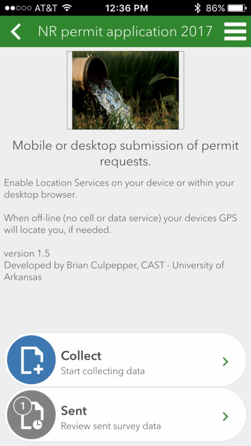
Streamlined Non-Riparian Permit Application (Mobile App prototype)
These Smart-forms will work within a desktop browser or within a free mobile application that isn’t dependent upon any app store placement and is supported by multiple device types. Security and future revisions to these smart-forms can easily be managed by ANRC staff.
Click here to access the application (requires login)
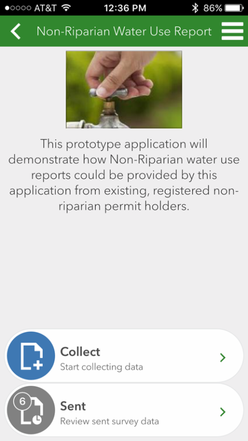
Streamlined Non-Riparian Water Use Reporter (Mobile App prototype)
This Smart-form based application will also work within a desktop browser or within a free mobile application and it’s set-up to enable ‘real-time’ reporting of Planned or Actual non-riparian water consumption from active permit holders. End-users can report any planned water use, and include the location of the withdrawal plus all other related contact information from almost any mobile device (even if outside of cellular service areas). These reports can be monitored in real-time from within the ANRC databases and within online/intranet maps so that these water consumption reports can be integrated into the decision-making processes within ANRC.
Click here to access the application
Integration of Enterprise DBMS Geodata Practices
Inclusion of geospatial capacity and analyses into the permitting review and analysis requires a robust, enterprise-level, multiuser data management system (DBMS) that is tightly integrated with GIS mapping services. We have proposed the adoption of the Enterprise ArcGIS software system that leverages open-source DBMS software (PostgreSQL) along with ArcGIS server which is compatible with ANRC’s existing GIS desktop software.
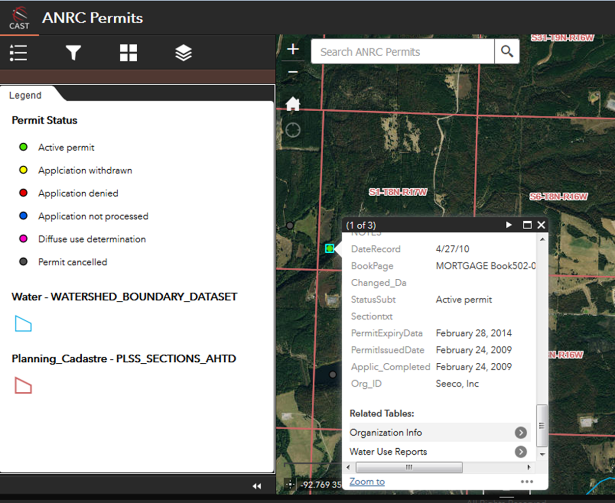
ANRC Permit Review
A read-only database view for use among agency collaborators as well as ANRC staff outside of the Non-Riparian team.
Storing these features (as a geodatabase tables with geometry) within a truly multi-user database enables the development of table relationships, and attribute domains at the database level, not just the application level so that data quality can be maintained among project team members.
Click here to access the application (requires login)
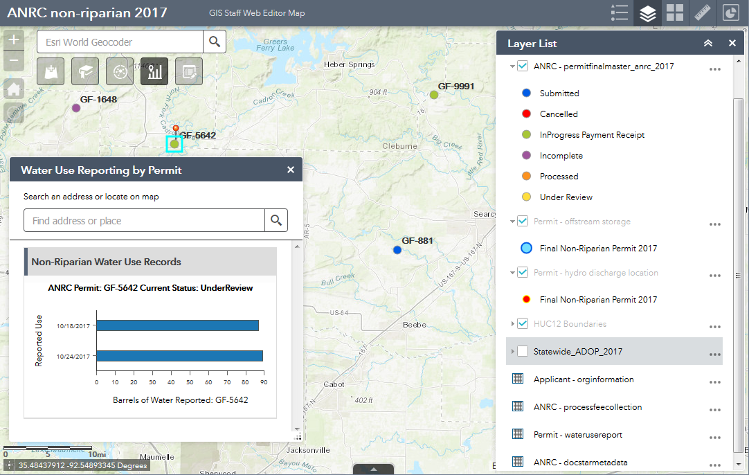
Geospatial Data Management Tools
The goal of this non-riparian system was to create powerful yet simplistic web-based mapping and geospatial tools that can operate as desktop applications directly through to web interfaces for public consumption. These extremely powerful web feature services allow the desktop GIS user to perform tasks normally limited to advanced database users because ArcGIS Desktop serves as their user-interface into an enterprise DBMS. Specific GIS tasks performed within the non-riparian program include: delineation of drainage areas, documenting non-riparian storage ponds, attachment of mapping attributes to individual database records, and the creation of mapping products for reporting and presentation of permit data. Mapping services may be designed to support field workers and improve standardization of tasks performed in the non-riparian permit and related water resource programs administered by ANRC.
Click here to access the application (requires login)
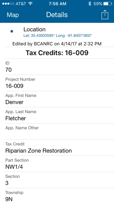
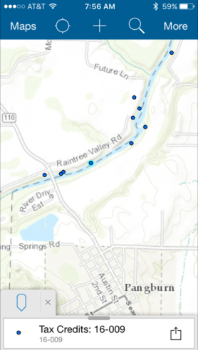
Mobile map applications for ANRC field work and site inspections
We have demonstrated to the ANRC staff how the use of a mobile phone or tablet can assist them while in the field by having seamless access to the geospatial data and editing capability of ArcGIS feature services via ArcGIS Server and the ArcGIS Collector app. Field verification of Tax Credit locations and a prototype Earthen Dam Inspection database schema were developed and demonstrated to ANRC Staff. These applications are secured within the ArcGIS Online framework but reference an editable geodatabase Feature table within our on-site and cloud-based Enterprise geodatabase system.
Standardized geoprocessing within ANRC’s existing workflow
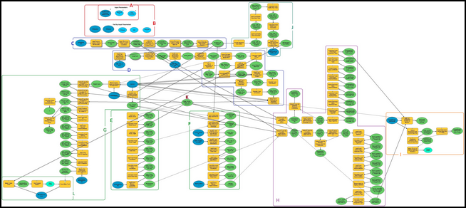
Decision logic and integrated programming should be developed through iterative discussions on which specific tasks could be automated within ANRC. Geoprocessing tools could help automate those permitting GIS tasks that are well-suited for standardization and also compliant with existing ANRC staff and agency software environments. Programming scripts could update web mapping services and geospatial datasets to help track and share non-riparian permit information (internally and externally), while ensuring compatibility with state GIS community.
These workflow examples demonstrate how some of the repetitive steps within the Non-Riparian permit evaluation process have been automated within the desktop GIS software.